A context for Yorke Peninsula in South Australia
This article was the basis of a talk to a community group (‘Friends of Gulf St Vincent’) based in Adelaide, South Australia , which is committed to improving the ecology and amenity of the Gulf St Vincent biozone. It was one of several talks given at a gathering of members of the Group and the local community in the Community Hall at Pine Point, a small village on the eastern coast of Yorke Peninsula. The focus of the meeting was the possible impacts on Gulf St Vincent of an impending open-cut iron ore-copper-gold-uranium mine nearby (Hillside Mine), but broader issues of environmental impacts and controls were discussed. Having earlier prepared and submitted a response to the Government regulator on the proposing Company’s submission of a mine and environmental management plan, my presentation at this meeting was broadly to overview mining and mine environmental management on Yorke Peninsula (in 20 minutes or so).
When faced with making a presentation on mining and mine environmental management, which is one of the issues that local communities are finding it increasingly difficult to deal with, I find it interesting and somewhat enlightening to take a step back and look at some history. Community perspectives on industry, and especially coexisting with large-scale industry, has changed in Australia over the decades. Perhaps with a historical perspective in mind, it might be possible to map a pathway forward to a productive and acceptable coexistence?
The following notes for my presentation are basically dot-points from a series of ‘slides’ which summarise the approach I’d taken in my presentation. I’m not sure how it went.
Mining & agriculture started early
- Both industries significantly changed landscapes. Mining – local but intensive disturbance. Agriculture – regionally extensive forest clearing but largely surface disturbance
- Communities benefited from & adapted to both enterprises – but regulation, attitudes & circumstances changed with time
- ‘Small’ farmer has gone; properties now amalgamated into large enterprises with fewer workers; rural towns & services have dwindled
- ‘Mines’ neither larger nor necessarily closer to population centres now than in the past are being viewed as environmentally damaging & socially disruptive
Some history of mining on Yorke Peninsula
- Copper mined from Wallaroo & Moonta from ~1860. Intermittent mining in 1930s & 1940s. Renewed exploration & from 1989 – 1994
- Parara Mine (west of Ardrossan) operated for Cu-Au in the 1870s; the Hillside & Harts Mines were opened further south at about the same time in a similar geological setting
- Salt mined & exported from Yorketown, Port Vincent & Edithburg from ~1874. Later developments at Price & Stenhouse Bay
- Gypsum mined around Yorketown (1870s), Stenhouse Bay & Marion Bay (1890s) for export for plasterboard production
- Calcrete mined almost everywhere for local building stone & lime mortar. Lime kilns were very common & lime was exported to Adelaide.
- Marine limestones mined for export as flux in Port Pirie Pb-Zn smelters from ~1896, mostly from quarries adjacent to ports
- Cement produced & exported to Adelaide from Tertiary limestone at Stansbury from ~1913 & quarrying continues to this day at Klein Point
- Dolomite produced from Cambrian limestone at Curramulka since ~1930s & from Ardrossan since 1948. Exported as refractory for steel furnaces in Newcastle & Port Kembla
- Construction sand now mined from a Tertiary paleochannel near Price for Adelaide building industry
Some history of agriculture
- First agriculture ~1846 at Stansbury on an ‘Occupation license’
- First pastoral lease in 1851 at Wallaroo
- Agriculture on Yorke Peninsula as a whole expanded from ~1869 with land clearing & crop production. Establishment & growth of port towns followed for export of goods; inland settlements & towns were established later
- Poor yields during early days of agriculture addressed by superphosphate additions to soils starting ~1892. High demand for superphosphate. Imported phosphate from Nauru (high Cd) & Christmas Island (high U) – widespread additions to South Australian soils
- New barley crop varieties introduced ~1901
- Extensive clearing of forest to produce additional agricultural land at ‘bottom end’ of the peninsula from 1950s – significant Cu & Mn deficiencies corrected by additives in superphosphate
- Widespread modern use of ‘direct-drilling’ in croplands with increases in use of herbicides, pesticides, fertilisers
Getting back to mining – what about minerals exploration?
- Basically, minerals exploration is controlled by geology. Main search areas are in the ancient basement rock complexes. Gawler Craton – Olympic Dam orebody in central South Australia, Wallaroo-Moonta mines in northwestern Yorke Peninsula; Curnamona Province in northwestern South Australia – Broken Hill mines.
Old crustal elements form the foundations of South Australia and some of the State’s largest orebodies are found in them. (Map from Preiss W V et al. 2002 MESA Journal 27, 39-53; http://bit.ly/1Tt4KZI) 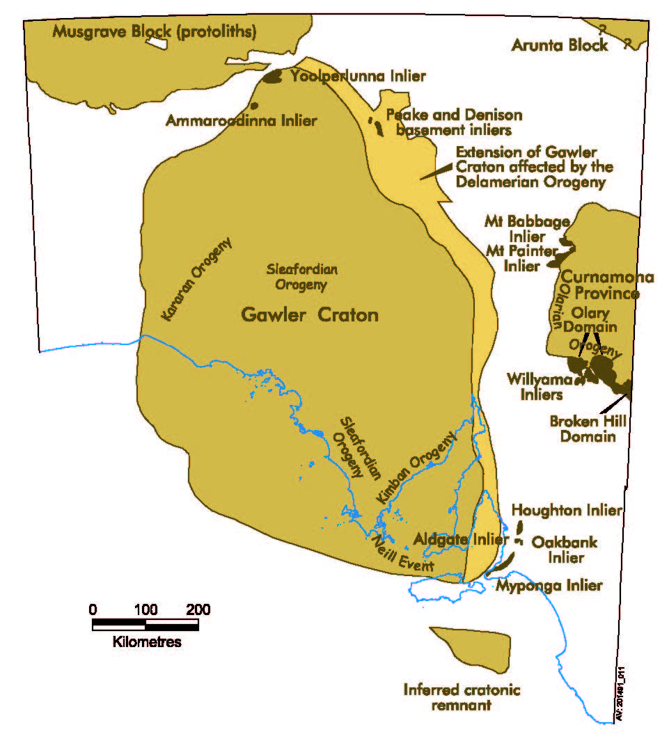
- In Australia all mineral deposits are owned by the Crown & the Government approves applications to explore (& possibly later to mine) – on conditions
Exploration
- Much exploration & analysis utilises remote sensing data – well before field work starts
- Exploration leases are granted on application to Government
- Drilling of target areas follows much deliberation, assessment, sampling & analysis (high costs)
- Success in finding an economic orebody is very low


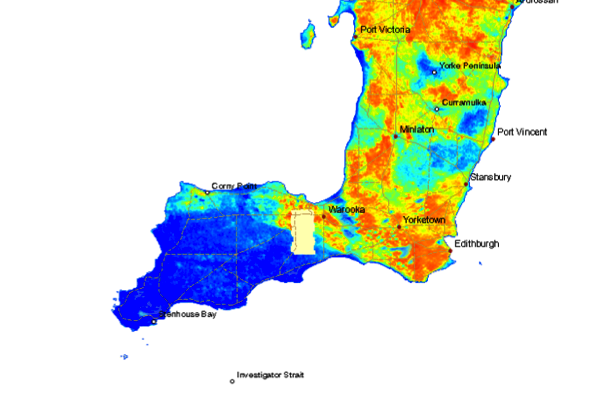
Airborne magnetics give clear indications of the geological makeup and structure (‘bones’) of the land at various depths beneath the surface (red = most magnetic rock; blue = least magnetic rocks). (Map from SARIG)
Airborne radiometrics provide unique information about the distribution of radioactive elements (K,Th,U) in surface rocks and soils from gamma ray signals (red = most potassium; blue = least potassium). (Map from SARIG)
Regulations
- If, after exploration, an orebody is discovered and assessed to be ‘economic’, Government approves (or not) an application to mine on conditions based on submission of a ‘comprehensive’ formal Proposal or Plan
- Legislation drives the process & the outcomes: Mineral Resources Division (Department of State Development) in South Australia is the regulator
- Consultation with landowners & communities (particularly at the exploration stage) can be inadequate. Community angst leading to ‘outrage’ is a common consequence
- Environmental management guidelines (& community expectations) can be ‘downplayed’ in favour of ‘public good’
- Company (& shareholders), Government (through royalties & taxes) & Community (employment, local Company spend, services) can all benefit from a mining operation. What about landowners? How is best to benefit neighbouring landholders?
- BUT legislation (& regulation) is generally inadequate in terms of environmental management & rehabilitation (post-mining) – can lead to significant environmental legacy
- Information about what can & can’t be ‘done’ should be readily available & clearly explained to communities. How? By whom?
- Community lobby can change legislation: best practice environmental management ‘guidelines’ should become ‘requirements’?
- Cost of mining projects must include the full cost of rehabilitation of project areas to something like that existing pre-mining according to best practice guidelines – not currently the case . Many mining projects would not proceed if this was the case!
- Mining companies & legislators should include community representatives on site-specific environmental management committees that operate for the term of the project and have ‘teeth’?
- Community groups must remain active & vigilant?
Summary
- Historically, mining has predated agriculture & other enterprises to ‘kick-start’ local economies, usually in ‘outback’ areas
- In time, agriculture & pastoral pursuits generally ‘subsume’ land after mining ceases, even though there are on-going environmental legacies
- Different forms of community development attach to mining & agriculture – community attitudes/perspectives change (and will continue to do so)
- Legislation drives environmental regulation – community attitudes & perspectives can help to change legislation
- Knowledge is key – monitoring & acceptance (or not) of impacts of any enterprise on local & regional landscapes ultimately falls to the community
- Change is inevitable – alertness, communication, regulation, adaptability, science all help
Some mining operations currently on southern Yorke Peninsula
Ardrossan dolomite quarry & port facility 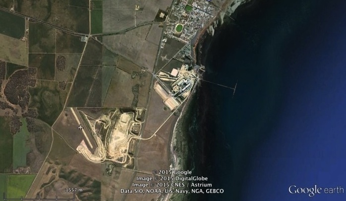
Klein Point limestone quarry & port operations 
Stenhouse Bay gypsum operations 
Price salt pans 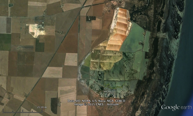
Dr A R Milnes

