Phillip Plummer & Tony Milnes
Visiting Research Fellows, Discipline of Earth Sciences, Adelaide University
Microbial life first appeared on Earth about 3.5 billion years ago and one of its forms became widespread and fossilized in the form of microbial mats (stromatolites) that are still extant today. More complex metazoan (multi-cellular, organized) life was a very much younger development: but just when did it occur?
The geological timescale was introduced in the nineteenth century and its Eras were defined on the presence and state of development of metazoan (animal) life as known at that time. Hence, Palaeozoic (from palaeo = old, between 540 and 250 million years ago); Mesozoic (middle, between 250 and 65 million years ago); and Cainozoic (recent, younger than 65 million years). The Proterozoic Era was thought to be devoid of metazoan life and so incorporated all time before the Palaeozoic (i.e. older than 540 million years).
When, in 1946, geologist Reg Sprigg discovered fossils of soft-bodied metazoans impressed upon the surfaces of Proterozoic Era sandstones at Ediacara, west of the Flinders Ranges, in South Australia, the scientific community received the news with scepticism. By definition, animals had not evolved before the Cambrian Period, the basal part of the Palaeozoic Era, so either the impressions were not fossils of early animals, or the rocks were not Proterozoic (i.e. pre-Cambrian) in age as thought. In order for his momentous discovery to be published, Reg Sprigg stated in the title of his paper that the sandstones were of Early Cambrian age, albeit followed by a “(?)”.
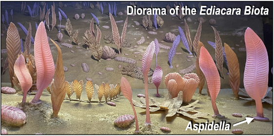
A decade later, the primitive frond-like metazoan fossil Charnia was discovered in the UK within rocks that, without doubt, pre-dated the Cambrian Period. And, within a couple more decades, fossils of the “soft-bodied Ediacara Biota” had been encountered globally within three assemblages, namely the Avalon Assemblage in Newfoundland, the White Sea Assemblage in NW Russia and the Nama Assemblage in Namibia.
But just how far back into the Proterozoic do these fossil assemblages extend? Radiometric age dating of volcanic horizons interbedded with the fossil-bearing sedimentary layers suggested that the Avalon Assemblage was no older than ca 578 million years while the White Sea Assemblage (which includes fossils from the Flinders Ranges) and Nama Assemblage were no older than ca 560 and ca 550 million years, respectively. Consequently, it became an accepted dogma that the earliest macroscopic metazoans (animals) had evolved ca 580 million years ago and that any metazoan-like impressions in rocks older than that must have been formed by some inorganic process or other.
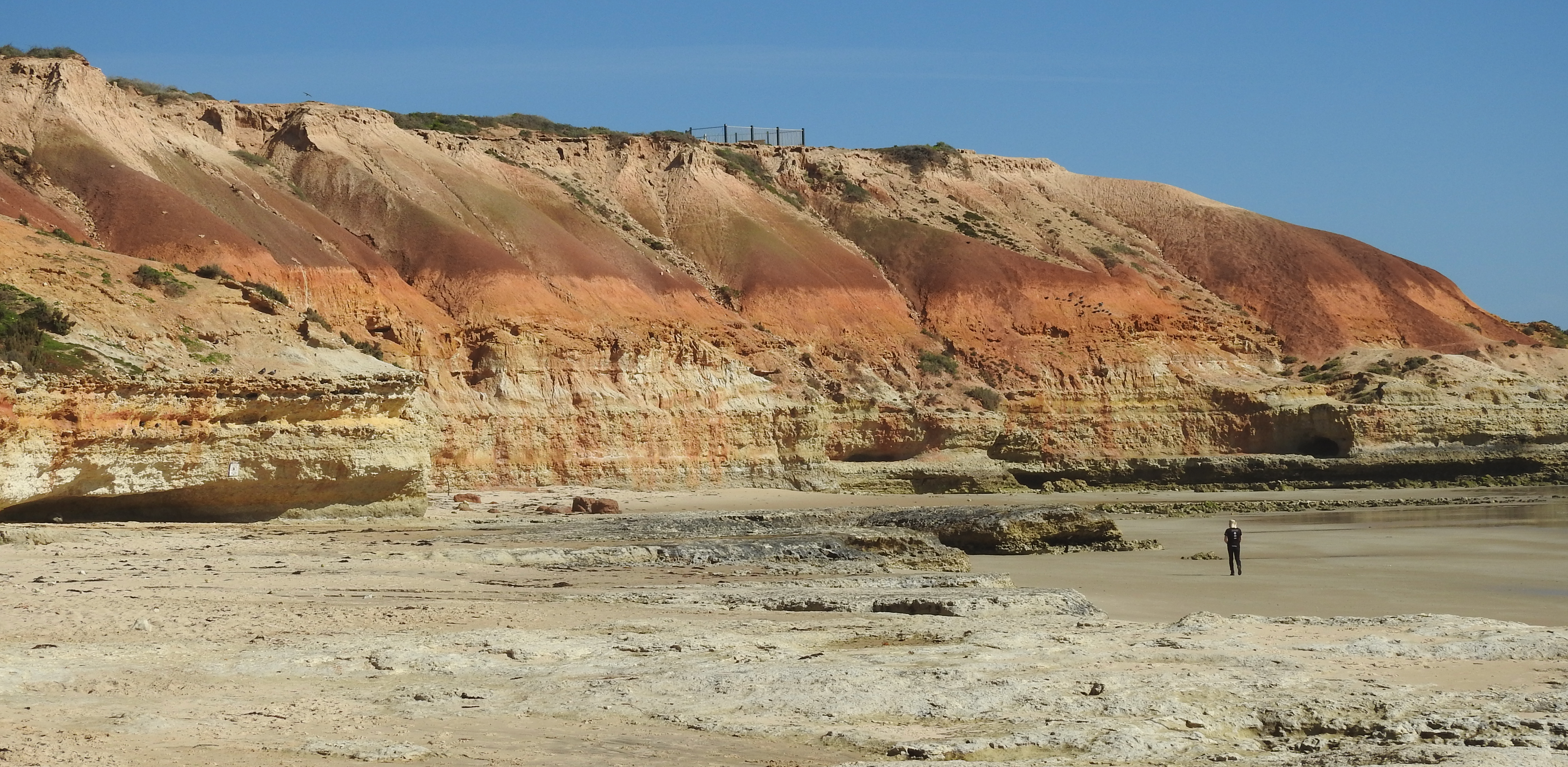
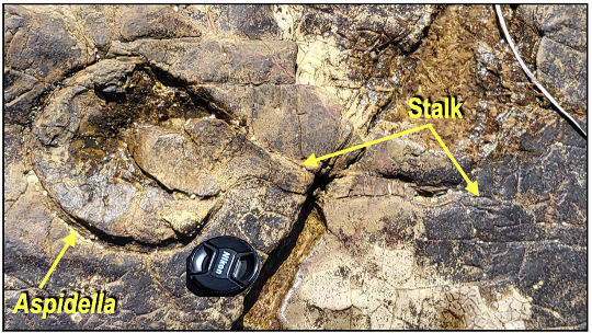
However, over the past couple of decades, metazoan fossils in rocks older than 580 million years have been discovered at several localities around the world, including a discovery we made of two large Aspidella with partial stems attached upon a wavecut platform south of Adelaide, South Australia. (An Aspidella is the point on the sediment surface where the stalk of a frond-like creature attaches itself to the seafloor.) These metazoans had clearly reached an advanced stage of cellular organization and function.
The rocks forming that wavecut platform are part of a sequence named the Brachina Subgroup consisting predominantly of reddish-purple shales and siltstones in packages 5 to 10m thick interbedded with 1 to 2m thick sandstones. The Brachina Subgroup is a correlative of similar deposits in the Sultanate of Oman, Himalayan India, the United Kingdom, Northwest Canada and China. These various sequences were deposited at a pivotal time in geological history after a series of glaciations (sometimes referred to as “Snowball Earth”) that occurred between ca 720 and 635 million years ago, and before the long-presumed moment of metazoan (‘Ediacara Biota’) evolution ca 580 million years ago.
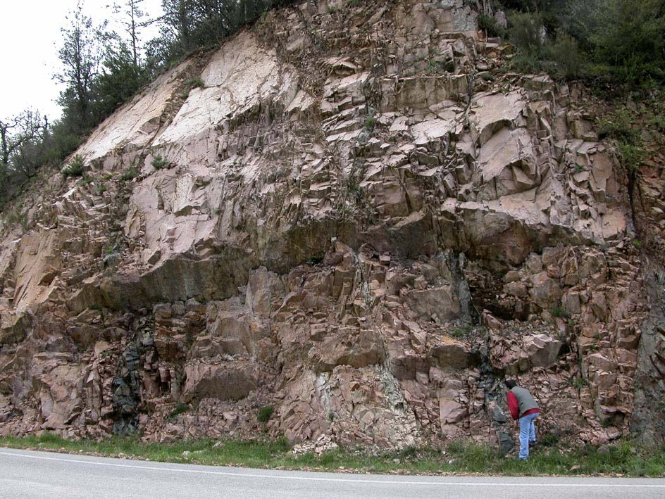
The Brachina Subgroup occurs throughout much of the Adelaide Rift Basin from south of Adelaide to the northern Flinders Ranges. It constitutes a large, fossilised delta system surrounded by an extensive shallow marine to intertidal mudflat (central and northern Flinders Ranges) deepening to a subtidal deltaic slope (southwards beyond Adelaide). The central unit of the Subgroup, the Moorillah Formation, within which the Aspidella fossils were found, dates to between 600 and 620 million years, at least 40 million years older than the Ediacara Biota of the Flinders Ranges/White Sea Assemblage. These Aspidella are not only the oldest, but also the most southerly occurrence of macroscopic metazoan fossils in South Australia.
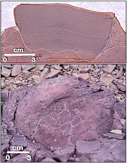
Flinders Ranges. BOTTOM: Underside of a similar cylindrical
structure from the age-equivalent sequence in the Oman
mountains.
These fossils are not, however, an isolated, reasonably advanced evolutionary occurrence. Fossils of similar age have been found in the United Kingdom, where the frondose Charnia fossils are now dated at 603 million years, and in China, where a group of fossils known as the Lantian Biota are dated at 602 million years. Also in the Moorillah Formation are numerous cylindrical to cup-shaped trace fossils that are interpreted to be dwelling hollows of anemone-like creatures. A similar cylindrical structure has been found in the age-equivalent Masirah Bay Formation in the Jebel Akhdar region of the Sultanate of Oman, thereby suggesting a global, rather than local, distribution.
These various fossils from the Moorillah Formation south of Adelaide do not represent a separate faunal group to that of the Ediacara Biota in the Flinders Ranges, but rather extend the time range of that biota from ca 560 million years back to perhaps ca 635 million years. Also, although these fossils are the oldest in South Australia, they do not represent the earliest occurrence of macroscopic metazoans on the planet. Elsewhere, in sedimentary rocks in both central Australia and central India, there are metazoan-like impressions described as being of organic origin.
If these can be confirmed they may indicate that animal evolution was perhaps not the smooth continuum from conception millions of years ago to today, as is widely assumed. Rather, evolution would have been a stop-start process involving local evolution and extinction, possibly involving several such cycles, before environmental conditions were suitable for metazoan (animal) life to proliferate globally. Perhaps we are witnessing the beginning of a new paradigm in our understanding of the origin and evolution of animal life. Is it possible that the search for life on Mars and other planets could benefit from this understanding?
Further reading
PLUMMER, P S & MILNES, A R (2025) New fossils from the Early Ediacaran (Neoproterozoic) at Ochre Point, Fleurieu Peninsula, South Australia. Transactions of the Royal Society of South Australia 149:1, 93-107. https://doi.org/10.1080/03721426.2025.2457170


_plates_Page_08")