Overview
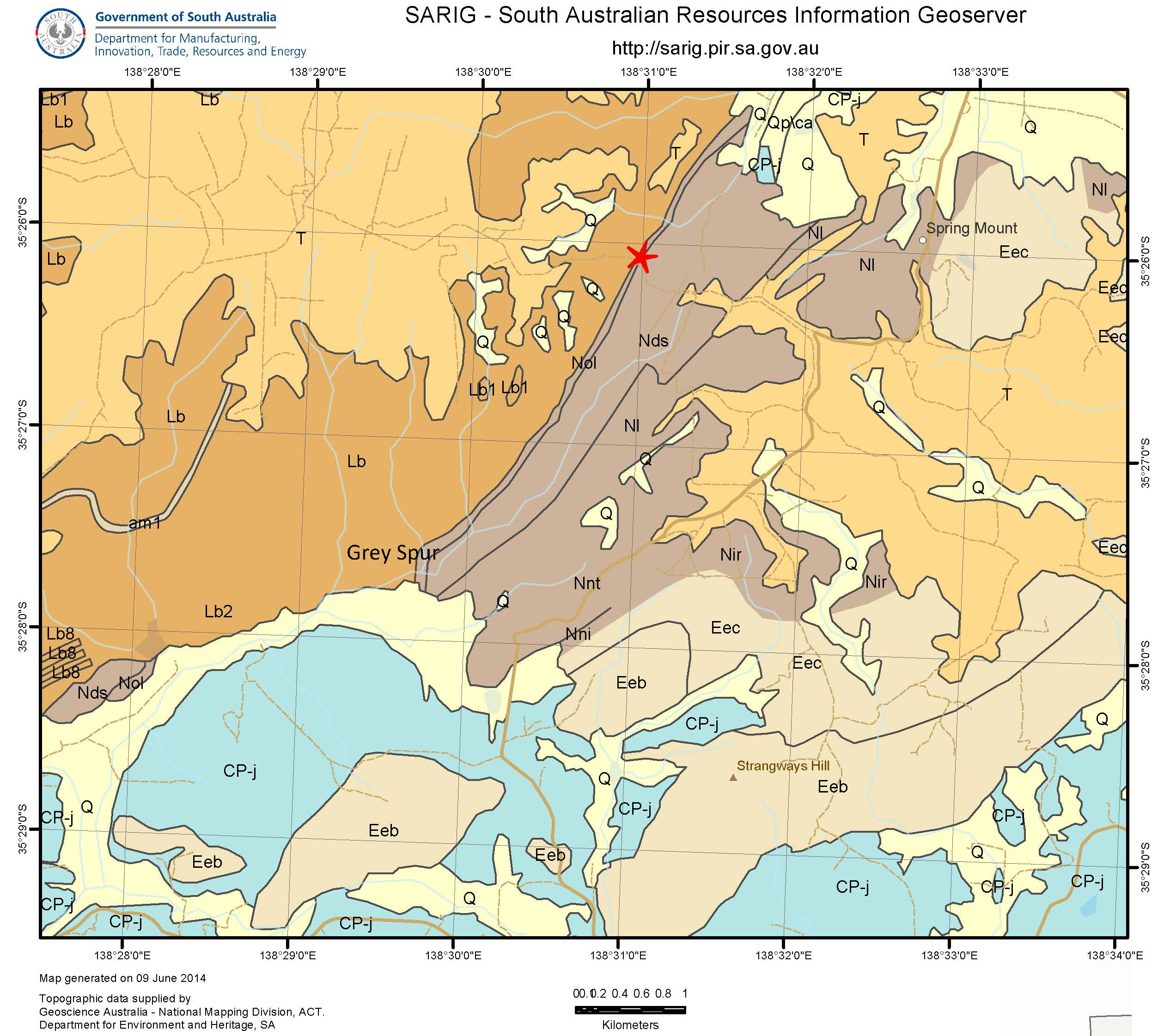
The earliest studies of glacial sediments and landforms of the Inman Valley, starting with Selwyn (1859), made much of the smoothed and striated bedrock pavements (which we now know to have been generated by the westward movement of ice sheets from continental regions that abutted southern Australia around 300 million years ago), and the large granitic and other erratics scattered throughout the valley. Much of the available information at the time, and hypotheses attached to it, were summarized by Professor Walter Howchin in 1926. Howchin’s map of the Inman Valley showed the locations of large boulder erratics (principally coarse grained, porphyritic granite similar to that exposed along the coast at Encounter Bay) and striated bedrock pavements, on which the directions of movement of the glacial ice could be measured. As might be expected, in-situexposures of glacigene sediments were observed directly overlying the pavements in some of these localities. Howchin remarked on the fact that changes in the courses of the Inman River and subsidiary streams over time continued to variously expose and also obscure rock pavements and overlying glacial deposits, and this situation has continued to the present day.
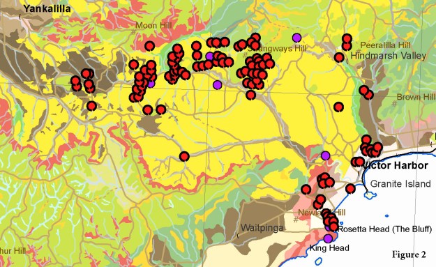
As well as at sites at which conspicuous large erratics occurred and striated bedrock pavements were located, Howchin assigned the sedimentary fill throughout the Inman Valley and adjacent areas to ‘Permo-Carboniferous’ glacigene deposits. This was partly due to borehole data that indicated diamictitic fill above bedrock in parts of the valley, but also because there were exposures of diamictite associated with the scattered striated pavements and erratics shown on his map (Fig. 1). This view was promulgated by successive geologists and dominates even the most recent geological maps of the area. However, as pointed out by Bourman & Milnes (2016), the fill in the valley is complex. It includes the remnants of glacigene deposits extensively eroded and reworked during Mesozoic and Cainozoic times as well as younger fluvial and alluvial deposits such as the peaty sediments of Pleistocene marshlands and sandy sediments resulting from post-European settlement erosion and aggradation. The soils map of the area (Fig. 2) is a good indication of this complexity as it presents at the modern landsurface.

-
Enhanced map of ‘greater’ Inman River valley by Howchin (1926) showing his locations of erratics (red dots) and striated pavements (with directions of ice movement – purple arrows). Region coloured in yellow was assigned to ‘Permo-Carboniferous glacial’ deposits; other coloured areas are bedrock of various types and ages.
-
Map of soils in the Inman Valley & surrounds showing locations of erratics (red dots – Howchin 1926; purple dots – recent field observations). Yellow indicates the dominant soil type – ‘G3: Thick sand over clay’ which corresponds closely to Howchin’s ‘Permo-Carboniferous glacial’ deposits and is promulgated on recent geological maps on which the soil mapping was based. Red = areas of ‘L1: Shallow soil on rock’ where bedrock is exposed or close to the surface on the steep slopes. Green = areas of ‘K: shallow to moderately deep acidic soils on rock’. Brown colours = areas of ‘F2: Sandy loam over poorly structured brown or dark clay’ soils, ‘E3: Brown or grey cracking clay’ soils, and F1: Loam over brown or dark clay in the modern stream valleys.
Erratic strewnfields
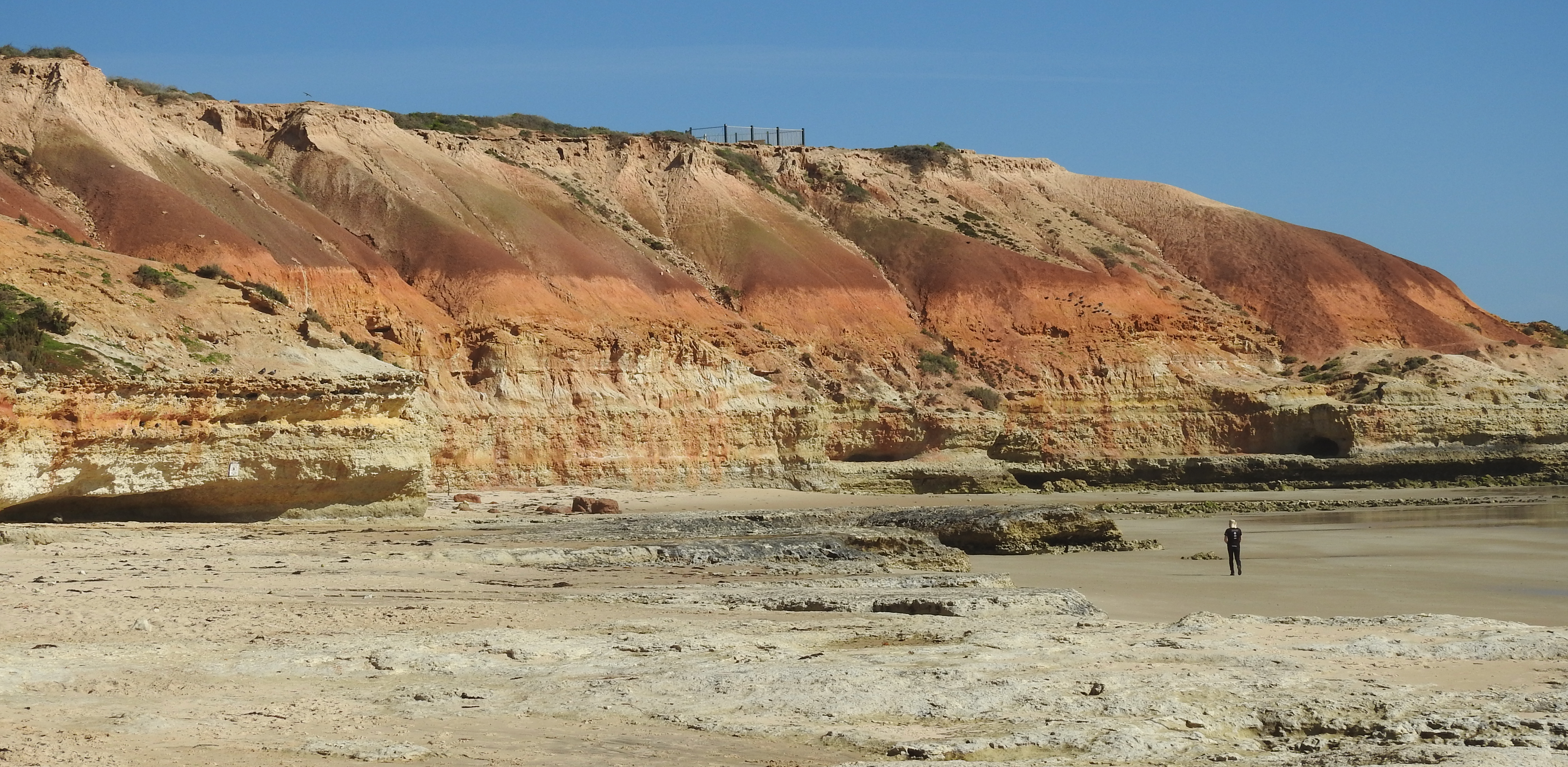
Recent field observations demonstrate that the strewnfields of large, mostly granite erratics (Howchin’s 1926 map, to which there are more recently added occurrences shown in Fig. 2), essentially pinpoint outcrop or subcrop of in-situglacigene diamictite from which they have been recently exhumed, or within which they still remain partly encased. The diamictite is generally plastered over smoothed and striated Cambrian Kanmantoo Group bedrock and may be ‘lodgement till’. Good examples of this are on the beach at Rosetta Bay, in dam excavations east of Mt Alma road, in the Inman River channel at Inman Valley township and for some kilometres eastwards, and at the site known as ‘Glacier Rock’. Elsewhere, Permian glacigene sediments have long been eroded and substantially reworked, and the granite erratics that have been exhumed from them have largely disintegrated and the weathering products dispersed. The stages in this process can be observed in some granite erratics now being exhumed from glacigene diamictite. Weathering and disintegration of granite erratics in association with Permian glacial diamictites does not occur to anywhere near the same extent in coastal environments, such as on beaches at Rosetta Bay, just north of Port Vincent and at Port Moorowie on Yorke Peninsula, and at Hallett Cove south of Adelaide.
Diamictites
Howchin (1926) referred to the diamictite as ‘.. glacial sandstone and boulder clay..’ and it is quite distinctive, as shown in the accompanying photographs. In locations near the coastline, for example in Rosetta Bay, the diamictite tends to be bluish in colour, with some bleaching and iron-staining, suggesting that weathering is not pervasive. In the main part of the Inman Valley, however, and particularly in the river channel, exposures are generally yellowish-white and bleached of colour. In the earliest reports (Tate et al., 1898), the glacigene sediments were described as being to be so dark in colour that they were thought to be potentially coal-bearing, and this led to exploration drilling of three bores in Back Valley by the Victor Harbour Coal Company. Carbonaceous glacigene sediments are known elsewhere, for example at Port Moorowie on southern Yorke Peninsula, but have not been observed recently in the Inman Valley. The beds of glacial origin that Howchin (1926)2referred to as being typically ‘.. tenacious blue clays..’ have also not been observed recently although the diamictite that is periodically exposed at low tide in Rosetta Bay and which underlies the conspicuous lags of large granite erratics, is bluish in colour.
The sandy-clay matrix of bluish-coloured diamictite is dominantly quartz, with feldspars and muscovite or biotite. Unexpectedly, in the samples examined so far, the clay is dominated by poorly crystalline 14Åmontmorillonitic material: no kaolinite was observed.

Collection of granite erratics in large strewnfield west of Mt Alma road

Lag of erratics overlying and being exhumed from diamictite adjacent to boat ramp.

‘Isolated’ granite and other erratics.

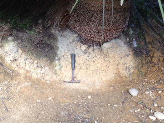
Smoothed & striated bedrock pavement overlain by diamictite containing large granite erratics (dropstones) in valley wall.

Diamictite beneath erritic lag adjacent to boat ramp. Note blue-grey colour of clayey grit matrix, mabundant small granite and other clasts, goethite staining and carbonate-filled fractures. 50c coin for scale.

Diamictite as in previous photos
1. Strewnfield of large granite erratics west of Mt Alma. 2. Lag of granite & metamorphic rock erratics on diamictite, Rosetta Harbor. 3. Lag of granite & other erratics over diamictite, bed of Inman River, east of village. 4. Disintegrating granite erratic eroding from diamictite, Strangways Hill. 5. Large granite erratic in diamictite on glaciated pavement, Glacier Rock. 6. Large granite & other erratics embedded in diamictite on glaciated pavement, bed of Inman River, east of village. 7. Bluish sandy-clay diamictite (‘lodgement till’) beneath lag of granite erratics, Rosetta Harbor. 8. Bluish sandy-clay diamictite with embedded granite & other clasts, Rosetta Harbor.
Summary
The strewnfields of large granite and other erratics in the Inman Valley are considered to represent vestiges of extensive Permian glacial diamictite. Remnants of these sediments in localities along the north-central and eastern parts of the valley have been exposed close to the ice-moulded bedrock walls and floor that have been progressively exposed by erosion. As downwasting continues, it is expected that the large granitic erratics now exposed in the boulder lags will gradually weather and disintegrate, as is common in terrestrial environments. New occurrences could emerge if riverine erosion exposes more of the original bedrock valley. On the other hand, rising sea-levels may trigger aggradation and the burial of the now exposed strewnfields of erratics, the associated diamictites, and the underlying glaciated bedrock pavements.
Although there have been many investigations of facets of the Permian glaciation, including landforms and sedimentary deposits, starting as early as Selwyn (1859)1, evidence of post-Permian geological processes in the Inman Valley up until the Quaternary has not been recognised. Some soil mapping linked with Howchin’s (1926) observations and more recent data reported by Bourman & Milnes (2016)2is the most recent information. Opportunities to discover more of the history of this complex landscape clearly exist.
References
Selwyn R.C., 1859, Geological notes of a journey in South Australia from Cape Jervis to Mount Serle, No. 20, p. 4.
Howchin W., 1926, Geology of the Victor Harbour, Inman Valley and Yankalilla districts, with reference to the great Inman Valley glacier of Permo-Carboniferous age. Transactions of the Royal Society of South Australia, 50, p. 89-116.
Bourman, R.P. & Milnes, A.R., 2016, The geology and landforms of the Inman River Catchment. Report to Inman River Catchment Landcare Group, Government of South Australia Department of Environment, Water and Natural Resources, December 2016. 237pp.
Tate R., Howchin W., David T.W.E., 1898, On the evidence of glacial action in the Port Victor and Inman Valley districts, South Australia. Report of Research Committee No. 5, Australasian Association Advancement Science, 7thmeeting, Sydney 1898, p. 114-127.
Dr Tony Milnes
_plates_Page_08")